PART I: AN OVERVIEW OF NEPAL AND THE KATHMANDU VALLEY
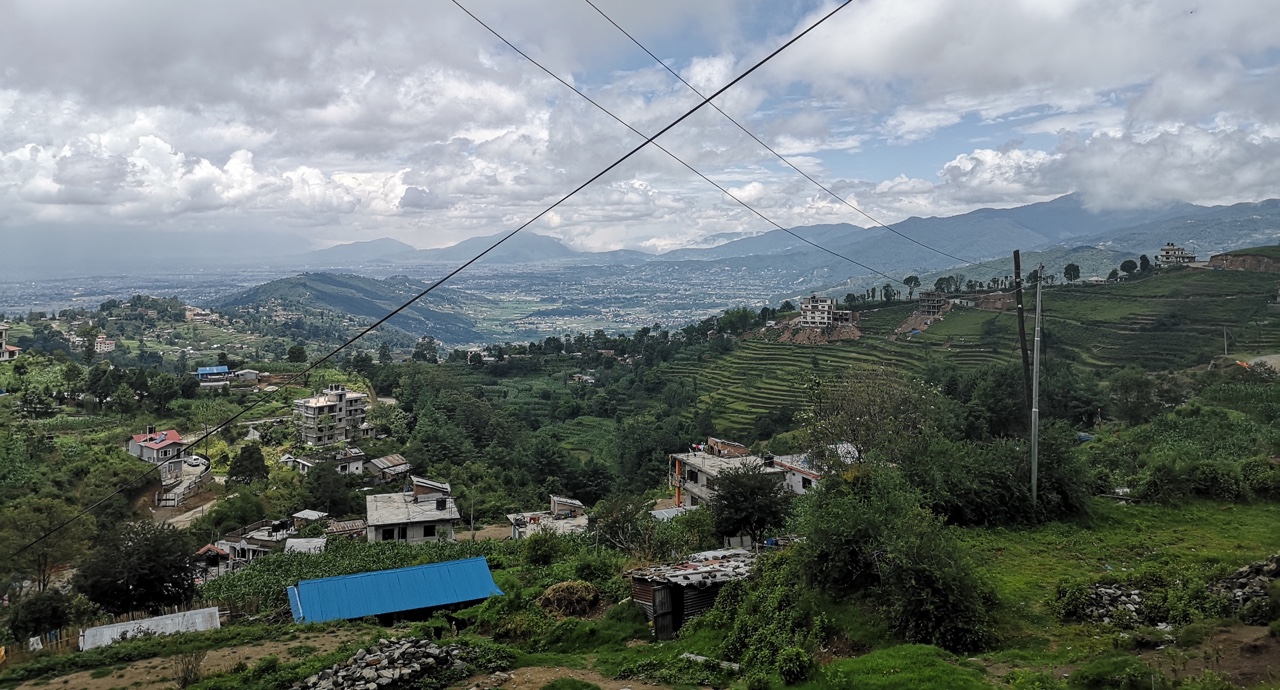
Nagarkot, a village in the hill region of Nepal, located on the outskirts of the Kathmandu Valley. 2019 © Astara van der Jagt
Nepal is highly exposed to natural disasters like floods, earthquakes, landslides, avalanches, and droughts, which is mainly due to its geography and climatic conditions.
In 2005, the World Bank released a Global Risk Analysis report that stated that the county is a ‘hotspot for geophysical and climatic hazards.’
The country is divided into three regions: the mountains (Himalayas) in the north, the hills in the middle, and the plainlands (Terai) in the south.
Each region is prone to environmental disasters for different reasons.
In the hills, landslides are common due to extremely steep slopes, high intensity of rainfall and unplanned human settlements. Landslides are even more likely when roads or irrigation systems are constructed without sound measures, which disrupt an already fragile ecosystem.
The mountains cause a different problem. The Himalayas’ snow-capped mountain tops and glaciers flow down to the hill and Terai regions, causing flooding that damage villages and crops.
However, sometimes, the opposite happens. The Terai regions suffer from droughts caused by irregular Monsoon rainfalls, which are supposed to last for three months between June and August, and supplies 75 per cent of the annual rainfall.
This year, Monsoon season came one month late. Two-thirds of Nepal’s farmland is rain-fed, making it the most important part of the year for farmers to plant their crops. Among the products cultivated during the rainy season is rice, Nepal’s most consumed staple food, supplying 40 per cent of the population’s food calorie intake, and contributing 20 per cent to the total agricultural Gross Domestic Product (GDP).
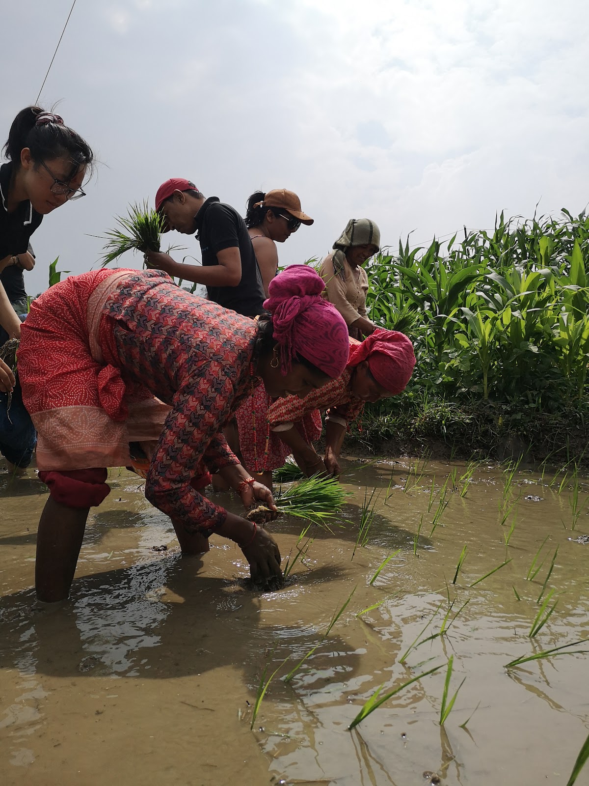
Newari women planting rice in Bungmati, a village 10 km south of the heart of Kathmandu. 2019 © Astara van der Jagt
Recent decades have been characterized by population increases and industrial growth. As a result, the Kathmandu Valley (KV) has suffered from environmental degradation and increased pollution.
The KV consists of three districts: the Kathmandu District, Lalitpur District and Bhaktapur District. Between 2001 and 2011, the total population of the three districts increased from 1.6 to 2.5 million.
However, investments in infrastructure, water disposal, wastewater management, and the reduction of air and water pollution have been lacking. Simply put, the rate of industrialization has not been able to keep up with the masses of people entering the KV due to environmental disasters, the civil war that lasted ten years and ended in 2006, and economic opportunities.
Alongside the influx of people, the KV has lost much of its agrariable land mass to planned but, more often unplanned, built-up areas. This has reduced the government’s ability to be prepared when environmental disasters do strike.
2015 was a prime example. Nepal suffered from two massive earthquakes, measuring 7.8 and 7.3 on Richter’s Scale respectively. Locals still regularly refer back to this ‘terrifying time,’ when the walls of their homes came tumbling down and thousands lost their lives. 8,790 died, to be exact, and 22,300 people were injured. Half a million homes were destroyed and even more were damaged. Today, many homes are still held up by wooden poles, or need rebuilding.

The building pictured above is home to Kathmandu’s Living
Goddess, a young girl who is believed to be the reincarnation
of Goddess Taleju, and is worshipped by both Bhuddists and
Hindus. Her home, too, is held up by wooden poles.
2019 © Astara van der Jagt
The widespread destruction of the earthquakes combined with the tethering
The KV is in dire need of trees and it seems that there is no shortage of initiatives pushing for greater environmental sustainability. The Nepali government, for one, has proposed to plant 50 million trees during the next fiscal year, starting on July 17th, 2019. The national campaign has been named the “Year of Plantation,” yet no accompanying scientific plan has been proposed to date.
Alongside the continued development of urban infrastructure responding to the needs of modernized societies, a scientific plan would help to minimize the negative impacts industries can have on the environment. Since space is very limited in the KV due to population density, unplanned settlements and large influxes of people, it is hard to imagine where millions of trees will be planted. The government has yet to release their geographical strategy.

Thamel, the main tourist district of Kathmandu. 2019 © Astara van der Jagt
By: Astara van der Jagt

Astara van der Jagt’s career spans half a decade on four continents. Equipped with a degree in journalism and political science, she has done research on the power of social media in Kenya, worked as an au pair in Italy, and learned about the ethical reporting of marginalized communities in Northern Canada. Earlier this year, she moved to Nepal to produce a communications strategy focused on empowering the rural poor for Sana Kisan Bikas Bank Ltd., an agricultural development bank based out of Kathmandu.
From a young age, Astara was exposed to gender-based violence, extreme poverty and water scarcity. Although she has found ways to turn her own pain into power, she still has so much to offer those who do not have the passports, opportunities and support systems she does. This is why she has committed her life to finding methods to overcome these global problems through grassroots action, helping one individual at a time, all while spreading awareness through her photography, videography, and storytelling.